Concello de Pantón
The town of the 3 rivers
Arribeirados will show you the municipality where we reside: Pantón, where we can enjoy the three rivers that make up the Ribeira Sacra, its landscapes, its Romanesque art, and its gastronomy.
The municipality of Pantón, in Lugo, with its 146 km2 and 26 parishes, belongs to the Terra de Lemos region and is part of the Ribeira Sacra.
Where is Pantón located?
The geographical boundaries of Pantón are determined by the Miño, Cabe, and Sil rivers, which make Pantón the “Galician Mesopotamia.”
The Miño River separates the municipality of Pantón from the municipalities of Chantada and Carballedo.
The Cabe River delimits the municipality of Pantón from the municipality of Sober and offers a bathing area in Areas.
The Sil River delimits the municipality of Pantón from Nogueira de Ramuín and separates the province of Lugo from Ourense.

Until the 1990s, we can say that this municipality was very prosperous thanks to trade, especially in meat, as this sector was focused on the main street of Ferreira de Pantón, where the old national road 120 passed. With the creation of the current highway, Pantón lost a lot of business and, consequently, purchasing power.
In 2020, it had a total population of nearly 2,500 inhabitants, compared to 5,500 in 1990. Currently, it is referred to as an “aging population” as 45% of the people are over 65 years old.
Ferreira de Pantón, the capital of the municipality, is strategically located in a quiet area 35 km from the city of Ourense, 80 km from Lugo, 135 km from Vigo Airport, and 125 km from Santiago de Compostela Airport.
What to do in Pantón?
In Pantón, we can engage in several activities: enjoy its three rivers, visit the Romanesque art in the area, go hiking, taste its wines in the local wineries, visit viewpoints, discover some of the most beautiful villages in the Ribeira Sacra, learn about its traditions such as the game of birlos or the carnival of the Cabe River, and all of this without leaving the municipality.
Shall we put on our hiking boots, wear some comfortable clothes, and go on a route?
Hiking routes that can be done in Concello de Pantón
Camino de Santiago de Invierno
The Winter way, on the stage that connects Monforte de Lemos with Chantada, crosses part of the municipality of Pantón, specifically the stretch that goes from O Reguengo to Galegos, a route of about 8 km.
In this section, we recommend stopping to admire the Pazo de O Reguengo and visiting the Church of Santiago de Castillón, of Romanesque origin, with its freestanding tower.

Route of Castro de Marce and Fervenza de Augacaída (Marce)
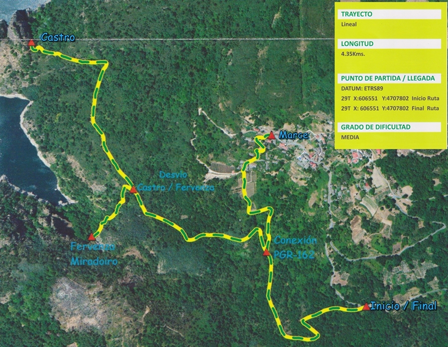
This linear route, 4.5 km in length, of medium to low difficulty, is one of the best-known in the entire Ribeira Sacra for its spectacular ending. The path will take us through lush native forests to an impressive waterfall. If we complete the full route, we will reach the remains of a castro from which we can contemplate the Miño and Chouzán.
After this beautiful route, we recommend visiting the village of Marce, once one of the richest in the municipality, where we will find the remains of a tower that belonged to the Count of Lemos and the Clock Tower, a construction financed by those emigrants from Marce who had to go to South America in the 20th century.
Route from Cibrisqueiros to San Cosmede (Pombeiro)
In this linear route of 4 km and low difficulty, we can enjoy beautiful views of the Sil River and abundant vegetation, the result of the Mediterranean microclimate. Throughout the journey, we will be accompanied by the sound of the Sil River as it flows towards the San Pedro reservoir.
We start our route in Cibrisqueiros (Pombeiro), a little further on, when we look back, we will contemplate a beautiful view of the Romanesque church of San Vicente de Pombeiro.
After a short but steep ascent, we find anthropomorphic tombs, the Tumbas do Preguntorio, on the right-hand side.
In some sections, we have to cross small streams and overcome fallen trees on the path.
We begin the descent among granite rocks, possibly remnants of a glacier. Some of the perpendicular rocks we encounter on the path are used for climbing, as evidenced by the anchors we discover on them.
We will cross a completely abandoned small village called Penabeada, the name refers to a rock, “pena,” shaped like a deer, “veada,” doe.
The undergrowth and trees prevent us from seeing some of the buildings.
During this descent, we will enjoy the views of Santo Estevo de Ribas de Sil, which, from a distance, watches over everything.
Towards the end of our route, a small chapel comes our way, which seems to be in use due to its cleanliness and lack of weeds.
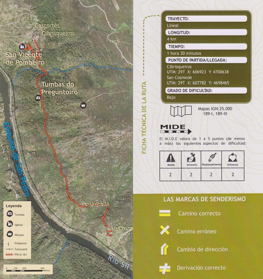
Our journey ends in San Cosmede, a town with numerous houses in a state of abandonment, in fact, one of them has parts of its overhang about to fall, and as we have to pass underneath… well, we have to be careful.
Route of A Curuxeira (A Arribada)
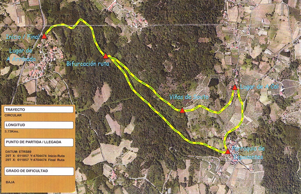
In this circular route of less than 4 km and low difficulty, we can enjoy lush forests and beautiful views of the Canyon of the Cabe River, as well as the lands of Sober.
A few meters from our starting point is the Augas Férreas fountain, ferruginous waters, which are very good for you but taste so bad!
We continue our journey and going downhill, we have two options: follow the path and reach Pacios, or cross a small bridge and go to Cal, both Pacios and Cal belong to Espasantes. In either option, the path brings us back to our starting point.
This route was conditioned years ago by a Jobs Workshop, creating wooden bridges to overcome some obstacles such as a stream.
How about we visit some viewpoints?
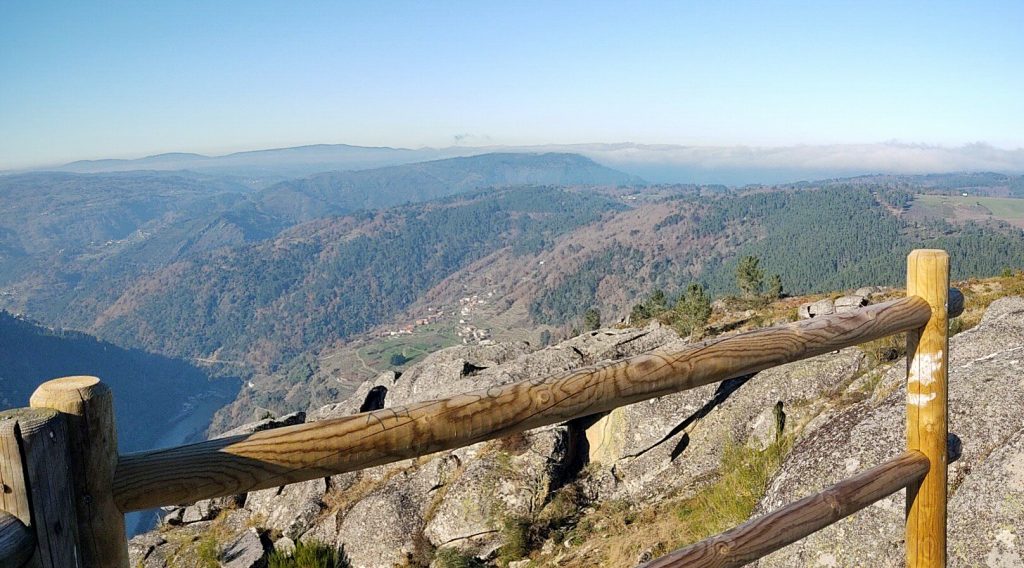
Pantón offers us two beautiful viewpoints that we can access by vehicle or by taking an 11 or 8.5 km route. Both viewpoints are located on large granite blocks, remnants of a glacier that gave capricious shapes to the rock formations. Let’s see what similarities we can find.
This area is known for being the land of “mouros” (spirits) and hidden treasures, we have not found any yet, but we have come across some deer.
Continue discovering Pantón

Lugares mágicos para visitar en otoño en Galicia
Galicia- Ribeira Sacra Adentrándonos en el corazón de Galicia nos encontramos una joya guardada entre las provincias de Lugo y Ourense, donde confluyen los ríos

Miradores Ribeira Sacra
En Arribeirados hemos querido escribir un post en el que aunaremos algunos de los más hermosos miradores de la Ribeira Sacra. Os explicaremos cómo son,
Senderismo Ribeira Sacra – Concello de Pantón
Rutas de senderismo en la Ribeira Sacra: Cascada de Augacaída y Ruta del Castro de Marce. Si hablamos de rutas de senderismo en la Ribeira
Así es el Entroido Ribeirao en Chantada (Ribeira Sacra)
Peliqueiros, puchos, diversión, color, gastronomía y tradición son los protagonistas de este singular carnaval gallego, conocido popularmente como Entroido Ribeirao. Te contamos qué lo hace


