Quiroga Municipality
Natural Beauty
Talking about Quiroga means talking about the beauty of its natural surroundings, nestled between the Serra do Courel and the valleys of the Lor and Soldón rivers.
This stunning municipality, one of Galicia’s largest at 317 km², is located in the province of Lugo. It borders León to the east and Ourense to the south, with the Sil River forming the boundary with the latter.
As we explore Quiroga’s lands, we will come across traces of its history, from Celtic hill forts like Pacios and Barxa to remnants of medieval fortifications, and even numerous remains of Roman-era gold mines.
In addition to man-made structures, nature’s creations will demonstrate its power and slow work over millennia.
Quiroga was declared a Site of Community Importance (LIC), and the Montañas do Courel Project has been part of UNESCO’s Global Geoparks since 2018, making it Galicia’s first geopark.
What to see in Quiroga, the capital of the municipality.
Museums in Quiroga
In Quiroga, we can visit its two modern museums:
Ethnographic Museum of Quiroga

Today, with over 1000 pieces, this museum is one of the most important ethnographic museums in Galicia. Currently, it is expanding to accommodate the numerous exhibited pieces, as they all deserve their place in this museum.
Geological Museum of Quiroga
This small museum was inaugurated in 2011 and expanded in 2020.
At the entrance, you will find an explanatory spiral panel about the main geological events in the history of Galicia.
Inside, you can watch a video explaining how A Serra do Courel was formed. About 350 million years ago, two major continents collided, raising the ocean floor to create the first land in the Galicia we know today.
The interior of the museum is divided into five rooms, each with its own content:
The first room is dedicated to the geological formation of the Galician territory.
The second room focuses on the paleontological history of Galicia, revealing that during the Quaternary period, animals such as bears, bison, and mammoths inhabited the area.
The third room discusses climatic changes in the Courel mountains during the Quaternary, including traces of the last glaciation, which can still be found in “a Lagoa da Lucenza.”
The fourth room is dedicated to the presence of the first humans in Galicia, introducing Elba, a shepherdess of the Courel mountains who lived there 9,300 years ago and is known to have had dark skin and lactose intolerance.
The last room explores the evolution of mining from prehistory to the present, as well as the use of water in mining operations and the process of making lime.
This museum is often visited by young students, as it offers insights into the geological formation of Galicia and the ancient inhabitants of the region, both animals and people, over thousands of years.
What to do in Quiroga municipality:
Visit Charming Villages - Paleozoic Village Route:
The beautiful village of A Seara is a prime example of the ethnography of the mountainous Ribeira Sacra.
In this cluster of houses, you can discover the unique characteristics of the villages in O Caurel, including slate roofs, stone buildings, and wooden galleries.
It is worth noting that there is a slate quarry in Quiroga, and this material is predominantly used for roofing constructions.
Another village on our paleozoic route is Campodola, where the stone used for its houses is associated with the distinctive geological fold of Courel.
Another magical village in the O Caurel region is Mazo, where you will find an ancient blacksmith shop and a village that has been rehabilitated for rural tourism.
Going on hiking routes
- The Route of Gold and the Royal Road, a circular route of medium difficulty spanning 15 km. This route begins in the beautiful village of Margaride de Lor, in the Covas do Medo (Caves of Fear), from here we ascend to the Castro de Ares. After several descents and small slopes, we return to our starting point.
- O Camiño do Ferradal, a linear path of medium to high difficulty covering 9.5 km. It starts in Ponte Soldón and ends at the Ruganda Foundry. This is an ancient path used for transporting minerals from the mountains. Along the way, we will pass La Cova de Ricopete, a wine cellar carved into the rock, and Pena Furada, where we can see a tunnel carved in the rock by the Romans to supply water to the mining operations.
- The Route of Lagoa de Lucenza, a circular mountain route of medium to high difficulty spanning 9.5 km. This route starts in the mountain village of A Seara and ascends to the Laguna de Lucenza, a glacial-origin lagoon. Along the way, we will encounter two of the most beautiful waterfalls in O Caurel: Fócaro and Navaregas. Upon reaching the peak of Formigueiros, we begin our return journey on the other side of the valley.
Discovering its waterfalls
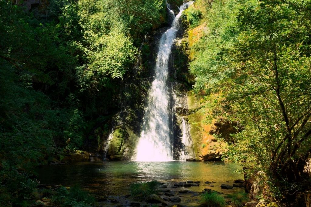
> La Fervenza de Vieiros, a waterfall about 20 meters in height formed by the Selmo River. Its crystal-clear waters and the surrounding nature make this place a paradise for wildlife and flora.
- We can follow a circular route of about 5 km that starts from A Seara towards Ferramulín. On our way, we will find some constructions called “sequeiros,” where chestnuts were dried.
- Take a one-kilometer route and leave our vehicle in the village of Vieiros.
> La Fervenza do Fócaro, this waterfall located in A Seara is one of the most impressive with its 30 meters in height and constant flow.
> La Fervenza da Pedriña – Cruz de Outeiro, this waterfall, also known as “A Pincheira da Pedriña,” located in Cuz de Outeiro, with a height of 7 meters, is very beautiful due to the image of the turquoise green pool in the middle of the forest.
Admiring beautiful landscapes from its viewpoints.
Quiroga itself is a geological monument, so between Campodola and Lexizós, we can contemplate the Campodola Fold, and from the viewpoint with the same name, we get the best view of the Courel Syncline.
However, we have two panels that help us understand what we are seeing. This viewpoint is located on the road that connects Quiroga with Folgoso do Courel via Alto do Boi.
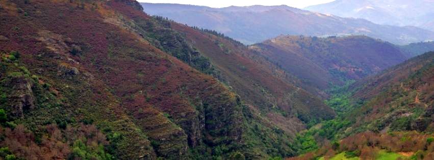
- Alto do Boi, with its altitude of over a thousand meters, is one of the natural viewpoints along with Pico do Pía Páxaro and Formigueiros, located at over 1,600 meters.
- From the Mirador de Anguieros, we can see the Montefurado Tunnel.
- In the village of As Covas, we find the Mirador de Castro de Ares, located in the Castro of the same name, with beautiful views of the Sil and Lor rivers and the Quiroga Valley.
- The Mirador de Bustelo. From this viewpoint, located at 610 meters in altitude, we can contemplate the Quiroga Valley formed by the Quiroga and Sil rivers. This viewpoint is located on the road that connects Quiroga to Serra de O Courel.
More Information
What to eat in Quiroga.
In the land of chestnut groves, we cannot miss trying their rich pastries made from chestnuts: jam, muffins, and cakes made with chestnut flour.
From the region, we can also taste honey and olive oil, the green gold.
At our table, we will not lack meat, whether it be from cattle or game. However, these should be accompanied by the wines from the Ribeira Sacra Designation of Origin of the Quiroga-Bibei subzone.
Its centuries-old traditions.
- To celebrate the pilgrimage of Our Lady of Remedios in A Ermida, on the 8th and 9th of September, one of the oldest and ethnographically valuable cultural manifestations takes place.
- El Meco (or “Felo”) personifies the devil, and the Pampórnigas, two giants representing a man and a woman, armed with brooms made of gorse, try to prevent the faithful from going to the temple where the religious ceremony is celebrated.
For all these reasons and more, Quiroga is a Municipality of tourist interest.


